 13 hours ago
15
13 hours ago
15
PROTECT YOUR DNA WITH QUANTUM TECHNOLOGY
Orgo-Life the new way to the future Advertising by AdpathwayTropical peatland fires rank among the most dangerous and stubborn fires on Earth. Instead of racing through trees and vegetation, these fires smolder through dried wetland soils and large deposits of peat, often continuing underground at relatively low temperatures. That makes them extremely difficult to extinguish and exceptionally polluting.
By one estimate, peat fires produce three times more fine particulate matter than other tropical forest fires, along with five times more sulfur dioxide, three times more organic carbon, and twice as much methane and carbon monoxide.
Satellite Images Reveal Indonesia's Fire Season
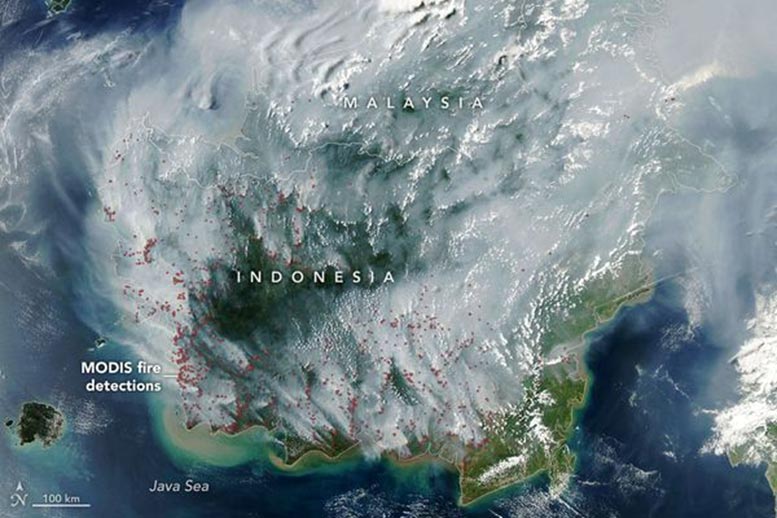
Indonesia's 2026 fire season was already underway when the MODIS (Moderate Resolution Imaging Spectroradiometer) instrument aboard NASA's Aqua satellite captured an image of the region on September 1, 2026.
On the annotated map, each red dot represents a "fire detection." This means the satellite sensor and an algorithm identified a pixel containing thermal anomalies associated with fire. A single fire can produce multiple detections.
Peat fires are a persistent problem in Indonesia, which contains about 36 percent of the world's tropical peatlands. During severe droughts, these normally wet landscapes can dry enough to ignite. Over the past three decades, such conditions have repeatedly produced long-lasting fires that blanket large areas in smoke for weeks and disrupt the lives of millions of people.
El Niño Is Intensifying the Dry Season
Wildfires occur in Indonesia every year, but some of the most destructive seasons in recent decades came during El Niño, particularly in 1997 and 2015.
NOAA assessed El Niño as present and strengthening in August 2026. The climate pattern commonly reduces rainfall across Indonesia. The drying can become even more pronounced when El Niño occurs alongside a positive phase of the Indian Ocean Dipole, which was also underway.
"Indonesia is only about three weeks into its fire season, but we're seeing fire activity track sharply upward, similar to 2015," said Robert Field, a Columbia University researcher who developed a tool called the Global Fire Weather Database that produces experimental, real-time fire weather forecasts.
"The strong El Niño is making the dry season drier over the fire-prone parts of the country and exacerbating burning -- just as we anticipated it would," he said.
The comparison with 2015 is significant. After more than three months of burning that year, Indonesia's fires had emitted 1.75 billion tons of greenhouse gas equivalents -- more than Japan emits in an entire year. By September 2, the 2026 fires had been burning for about a month and had already released roughly 10 percent of the amount produced during the 2015 crisis.
Underground Peat Fires Can Burn for Months
Indonesia was also experiencing severe, widespread drought during the summer of 2026, much as it did in 2015. Data from the Indonesian meteorological agency showed that about 90 percent of the country received little or no rainfall in early August.
Under normal conditions, peat deposits in Kalimantan, Sumatra, and Papua are too wet for fire to move underground. Drought changes that dramatically, allowing flames to enter the peat itself and continue smoldering below the surface.
"Surface fires are less of a concern, but when fires get underground, they just won't stop," Field said. "They'll keep burning until the rains come in October or November."
Indonesia relies on observations from NASA and NOAA satellites to follow active fires in near-real-time. MODIS and VIIRS are among the main instruments used. Indonesia's Ministry of Forestry operates the SiPongi fire-monitoring platform using MODIS and VIIRS data, and the system counted 946 hotspots on August 31, 2026.
The Worst Fires Can Be Hardest to See From Space
Satellite monitoring has important limitations, however. MODIS and VIIRS can struggle to detect fires hidden by thick smoke or clouds, burning beneath the forest canopy, or smoldering underground inside peat deposits.
In fact, when Indonesian fires become especially intense, the number of fires detected by MODIS or VIIRS can sometimes decline because the smoke itself blocks the satellites' view.
"The worst smoke events, paradoxically, can be the hardest to observe from space with MODIS and VIIRS," said Mark Cochrane, an ecologist at the University of Maryland Center for Environmental Science who has conducted field research on peat fires in Indonesia for nearly a decade.
Some of Indonesia's modern fire vulnerability can be traced back decades. According to Cochrane, extensive construction of irrigation canals and drainage of peat swamps during the 1990s, undertaken in part to create massive rice farms, lowered water tables across wetland areas and made the landscape more combustible. Oil palm plantations and other plantation forestry are also widespread in the region.
Following the unusually grim fire season of 2015, governments and other organizations attempted to reverse some of that damage. Projects have included blocking irrigation canals to help restore wetlands, strengthening firefighting capabilities, and stepping up efforts to prevent accidental human ignitions.
2026 Could Be a Major Test of Fire Protections
"This year will be a real stress test of the measures that were put in place after 2015," said Shi Jun Wee, a University of Maryland graduate student.
Wee is part of a team working with NASA and MapBiomas to develop improved methods for spotting understory fires that MODIS and VIIRS may miss. Their approach uses shortwave infrared observations from Landsat and Sentinel-2 satellites.
As the 2026 fire season continues, Wee plans to follow conditions using NASA's Worldview data browser, FIRMS (Fire Information for Resource Management System), HLS (Harmonized Landsat and Sentinel-2) observations, and GFED (Global Fire Emissions Database).
Hazardous Smoke Is Already Disrupting Daily Life
For people living in Indonesia and neighboring countries, the effects are already being felt. Indonesian officials have warned that large portions of the population have been exposed to hazardous smoke.
According to news reports, some schools have begun switching to remote learning, nine national parks have closed, and several flights have been delayed because of heavy smoke.
Cochrane cautioned that attention to the problem often rises during major El Niño fire seasons and fades once conditions improve.
"People tend to focus on these fires during an El Niño and then forget about them," Cochrane said. "We need sustained focus, even during the years when they aren't as bad, to solve this," he said. "These fires create a tremendous amount of emissions."












.png)





.jpg)



 English (US) ·
  French (CA) ·